Of all the wild mountain regions of Georgia, Tusheti is the wildest.

Tucked into the far northeast reaches of Georgia along the Chechnya border, Tusheti delivers again and again on its reputation for dangerous roads, stunning terrain and passionate people. In fact, Georgians sometimes refer to friends from Tusheti as giji Tushebi, or “crazy Tushetians”, much in the way Americans might describe their whacky Cajun friends from the bayous of Louisiana, or good ol’ boys from the hills of West Virginia.
These mountains, like most of the Greater Caucasus Mountains of Georgia, are best experienced on foot. Accessible only a few months a year, Tusheti remains hardly touched by tourism and boasts pristine hiking trails through dramatic valleys dotted with ancient koshkebi defensive towers and animist khatebi stone shrines. Shepherds flood the Tusheti valleys with massive herds of sheep every summer, yet the sheer magnitude of the terrain reduces the herds to tiny white puffs in the distance, shifting ever so slowly in their sea of green pastures like lonely clouds on a calm, sunny day.
And the sheep love it – the combination of fresh mountain air, clean alpine water, and an all-natural diet provides them with the essential elements for what becomes a staple in the Georgian diet – fresh cheese. In fact, ask any Georgian about the best dairy region in Georgia, and they will undoubtedly list Tusheti at the top of their list. Cheese for Georgians is like beer for Americans – personal preferences can be strong.
Make time for Tusheti. You’ll have to endure single lane dirt tracks along mind-boggling switchbacks and stomach-churning mountain passes to get here, but that’s kind of the point. And as any shepherd might tell you, the air, water and earth are worth the climb.

Time Needed
Four to five days at an enjoyable pace.
When To Go
July through August is your best bet. Late June and late September are your “shoulder season” limits – always check with the National Parks office if you are considering these times of year.
Distance and Elevation
75km, 3000m gain, 3600m descent
Difficulty
Strenuous
Distance from Tbilisi
That’s a bit complicated (see “Transportation” below). And if you do this hike, this depends on which direction you decide to go (Shatili to Omalo, or Omalo to Shatili).
Driving time to Omalo is about seven hours from Tbilisi, not including potential waiting and transfer time and/or negotiations (not to mentioned the occasional traffic jam…of sheep).
Driving time to Shatili is about four hours from Tbilisi.
Reason to Go
Pristine alpine hiking, otherworldly defensive koshkebi stone towers, animist relics, stunning river valleys, ancient shepherd trails and mountain passes, and one of the craziest roads in the world. Tusheti is the wildest of Georgia’s mountain regions.
Transportation to/from Tusheti
This depends on which direction you decide to hike.
If you choose to start in Omalo and hike to Shatili, it takes two hours to get to Kvemo Alvani village (by car, taxi, or marshrutky) – Alvani is the village in the Kakheti valley at the entrance to the Tusheti mountain region. This trip ranges from 100 GEL for a car/taxi, to ~10 GEL for a seat on a marshrutky. In Alvani, you’ll need to hire a 4WD car to make it to Omalo, which will take four to five hours (and goes along one of the most wild roads in the world). 4WD passengers will pay about 50GEL each, or 250-300 GEL for the whole car. In the high season, they will be waiting for you at the main/only intersection in Kvemo Alvani (especially if you get there in the morning, which is recommended).
Hiking from Shatili to Omalo, you’ll just do this in reverse – hire a 4WD out of Omalo (they will be everywhere as long as you get there before noon) and transfer to a taxi or marshrutky once in Alvani.
To get to Shatili, you’ll need to hire a car/taxi or get a seat on one of the marshrutky heading there twice a week at 0900 from the Navtlughi Station (near the Samgori Metro Station). 4WD is not required for this trip. This can change, so your best bet is to ask your guesthouse or accommodation – they can easily find you an updated answer. Same for getting back to Tbilisi – though your best bet will be marshrutky, which depart nowadays on Thursdays and Sundays.
Places to Stay in Tusheti
In this region, not only will guesthouses be your best bet, but they are also the most convenient and practical. Check booking.com for the latest accommodation options.
If you are doing the Shatili-Omalo hike, you’ll have the opportunity to stay in any of the various villages, depending on your pace. However, you should be prepared to camp at least two of the nights because of the distances in between.
Places to Eat in Tusheti
Similar to accommodations, you’ll be able to find some simple guesthouses serving food or basic snacks in each of the smaller villages. Omalo will obviously have the most options, as it is the most accessible village. And in Georgian guesthouse tradition, not only will you get dinner and breakfast, but they’ll also be willing to send you off with a simple lunch (in addition to putting you to sleep with a powerful buzz, if you’re interested!)
Otherwise, as mentioned above, you should pack enough food for at least two nights on your own (not including snacks, etc.) Water bottles can be filled up along the way at any of the village and/or mountain springs.
Regional Combinations to/from Tusheti
Whether you are heading to these regions for some photography or planning a multi-day trek, there are several ways you can tack on other worthwhile sights along the way.
Whether you start or finish in Shatili, make sure to spend a few hours wandering through the medieval village itself – it is completely unregulated, like most sights in Georgia, and a respectful stroll through the various tunnels and homes within the stone complex will be a once in a lifetime experience.
And if you are completing this hike in September, check online for the dates of the Shatiloba Festival. This local folk festival celebrates all things mountain culture – folk music and dance, horse races, wrestling, local booze, and many, many khenkali to fill in the gaps (khenkali was apparently born in Khevureti, the surrounding region). Shatili village serves as the wonderful backdrop of the festival, celebrated along the river in the valley below.
Heading back to Tbilisi from Shatili, a stop in Mtskheta (along the way) is also worth your time. The original capital of Georgia and it’s spiritual heart to this day, it also is said to be the location of Christ’s robe from the crucifixion.
Finishing in Omalo, there is no better way to rest and recuperate from a challenging trek than with a leisurely winetasting tour in Kakheti.(though a soak in the sulphur baths in Tbilisi should also occur at some point). Consider basing yourself in Telavi for a tour of the Alazani Valley below – an Upper and Lower Loop from Telavi is a great way to organize your time. And while you’re at it, spend a night or two in Sighnaghi to explore the lower Alazani Valley– you’ll sometimes feel like you’re in Tuscany.
And before making it back to Tbilisi, consider a short, half-day detour to the infamous cave monastery at Davit Gareja. While this semi-desert region along the border with Azerbaijan will stun your senses, the cave complexes will truly take your breath away.
Resources for Tusheti

The Tusheti Trek from Shatili to Omalo
Most people will break this trek into four or five days at a reasonable pace. And some will argue that walking from Omalo to Shatili is preferable due to the nature of the ascent and descent. These arguments are all perfectly valid.
However, due to your author’s timeline and the date of the famous Shatiloba Festival, this description begins in Shatili with the unique mountain cultural celebration and continues with the walk to Omalo the following day. The trek is equally stunning this direction, but more challenging in some ways due to the nature of your ascent and descent. This description and route is also unique in that it had to be completed in three and a half days – no small feat in the Tushetian terrain. This meant four long days of walking – not a bad thing in Tusheti!
Below is the standard itinerary. Due to your author’s timeline, though, the photos and descriptions will reflect a slightly altered schedule and route. This basically meant walking as long and far as possible each day, setting up camp only when a suitable patch of grass could be found (generally near the river bed).
Also important to note is that these pictures and descriptions reflect conditions the second week of September, just for your awareness.
Standard Itinerary: Omalo to Shatili (see this blog for details)
Day One
Omalo – Dartlo
11km, 400m gain, 700m descent
Day Two
Dartlo – Girevi
14km, 400m gain, 200m descent
Day Three
Girevi – Kvakhidi Meadows
14km, 1000m gain, 600m descent
Day Four
Kvakhidi Meadows – Khidotani Ridge
17km, 1400m gain, 1200m descent
Day Five
Khidotani Ridge – Shatili
20km, 300m gain, 1500m descent
ChapDaddy’s Itinerary (Shatili to Diklo)
Day One
Shatili to (grassy plateaus just below) Atsunta Pass
~30km and a lot of gain
Day Two
(Grassy plateaus just below) Atsunta Pass to (1-2 turns just short of) Chontio Village
~25km, a short, steep climb up to the pass and then a gradual descent into Tusheti
Day Three
(1-2 turns just short of) Chontio Village to (grassy patches 2-3km past Dartlo)
~20km, limited elevation gain along the river
Day Four
(Grassy patches 2-3km past Dartlo to Diklo)
~15km, relatively flat to Chigo, then steep descent, river crossing, steep ascent, and steep descent again into village of Diklo
For a variety of reasons mentioned above, this hike began in Shatili. The drive from Tbilisi takes about four hours and, once off the Georgian Military Highway, becomes a continuous, stunning view of steep valleys and rolling mountains.

Heading from Tbilisi towards Khevsureti, you’ll first have to climb up and over the Datvisjvari Pass (2676m), open only May through September most years.

Once up and over the pass, you’ll begin the beautiful descent into Khevsureti, the Argun Valley, and eventually Shatili.
Your arrival in Shatili will happen in stunning fashion. After following the river through a narrow valley and gorge for a few kilometers, you’ll begin to see a few homes before a final turn reveals the dark, stone village above you, almost as if frozen in time.

Shatili, built between the 7th and 13th centuries, sits atop a rocky outcrop overlooking the Arghuni River.
If time permits, a stroll and scramble in and around the stone village is worth it. Not only is it completely unregulated, but you’ll most likely have the place to yourself.

Like many sites in Georgia, Shatili is completely unregulated. A stroll through the ancient village is well worth your time.

You’ll notice that the entire village is built from the slate stone found in the surrounding valleys.

The village also has some particularly impressive balconies overlooking the beautiful valley below.

Some of the interiors are equally stunning.

In many cases, the stone walls are built directly on top of stone outcroppings, as shown here.

Walking out of Shatili and upriver, you’ll be able to look back and fully appreciate both the immensity of the Khevsurian terrain as well as the defensive nature of the regional villages in the valleys.
If you look closely, you can just barely spot the stone village of Shatili tucked beneath the massive mountain.
3km northeast, you’ll want to visit the Anatori Crypts. These medieval tombs are the resting place of villagers who, in times of plague, voluntarily (and possibly involuntarily) came here to die in isolation after contracting the disease. Bones are still visible as you peer through the iron gates.

The Anatori Tombs are located along the road upriver from Shatili, just before the trails heads south towards Mutso.

Peering through the windows, human bones are clearly visible.
Further up the river about 9km is Mutso, an equally stunning abandoned stone village sitting high up above the valley. Construction was ongoing in recent years to accommodate tourists, however the koshki towers and stone fortresses are still worth the climb.

Continuing south towards Mutso.

One of the greatest things about hikes in Georgian mountains is that you rarely have to carry an enormous amount of water. Every few kilometers, you are bound to come across a natural spring, or natural but modified spring, as shown above. Many even come equipped with a canteen cup, eliminating the need for you to drop your pack and pull out your water bottle.

You’ll know you’re close to Mutso when the first defensive koshki tower reveals itself.

Mutso is another example of a spectacularly placed stone village atop a rocky outcrop above the valley. As you can see by the orange safety container, construction is ongoing to accommodate more tourists.

Villages like Mutso must have been an incredible sight in medieval times – either terrifying to an intruder, or breathtakingly beautiful to an outsider. You’ll find the views most stunning from a distance – from afar, you’ll have a far better appreciation for the terrain and the strategic, defensive placement of the villages within the massive valley. There would have been literally no other way to move men and supplies through this terrain than by following the river valley.
Continuing past Mutso, the trail will hug the river, so tightly in some places that you’ll actually have to cross once or twice to avoid steep ridges or washed out banks. (You’ll also encounter some Georgian Border Guards – just have your passport available.) This changes year to year due to flooding, and hasty bridges will almost always be built to accommodate both tourists and (more importantly!) seasonal shepherds.

Some bridges will be fairly sturdy and well-constructed…

….whereas others may consist of two logs strewn from bank to bank, with a few misshapen stones erratically stacked on top. Enjoy!

A few kilometers past Mutso, you’ll cross the river one last time before encountering a series of steep switchbacks. Here, you’ll gain elevation rapidly and eventually arrive at Khidotani Ridge with sweeping panoramic views.

Khidotani Ridge is a wonderful reward for the punishing switchbacks up from the valley. You’ll also have another pleasant opportunity to interact with some more Georgian Border Guards. Located at the base of the ridge, they normally work for two weeks at a time (with a great view from their “office”) followed by a week off with family.
Local Tushi people are smart enough to bring a horse most of the time.

Continuing up the Khidotani Ridge, you’ll eventually begin to hug the left side of a steep bank heading up to your right (this photo is looking back).
Eventually, you’ll arrive at a series of grassy plateaus perfectly suitable to set up camp. Up above will be the dark, gravel stone pathway leading to the Atsunta Pass. You can save the steep ascent to the pass for the morning, enjoying the sunset in comfort. Pictured above is the view looking back towards Khidotani Ridge.

Your view in the morning at the base of Atsunta Pass will likely be stunning as well. Any fog/cloud cover that arrived at dusk should have settled deep in the valley come morning – and by the time you make it to the pass, it will likely have enough time to burn off, leaving you with unobstructed panoramic views from 3400m.

After the lush pastures and forested valleys of Khevsureti, the Atsunta Pass will feel like Mordor from Lord of the Rings. The dark, volcanic, steep and jagged terrain fills the trail with unforgiving stone dust and unstable piles of loose shale. For every two steps forward, you’ll likely slide one step back when carrying a heavy pack.

Once atop the ridgeline at the foot of the pass, you may encounter some strong wind pushing fog and/or cloud up and out of the cold Khevsureti side of the pass into the sunbaked Tusheti side of the pass.

From Atsunta Pass, you’ll be able to see clear distinctions between the Khevsureti and Tusheti sides of the mountain. On the left is the dark and windy Khevureti side, and on the right is the sunbaked, warm and lush Tusheti side. This like reverses at sundown, but hopefully you won’t ever find yourself atop the pass at sundown…

The descent down towards the Kvakhidi Meadows and eventually the Alazani River is as equally stunning as the ascent up to the Atsunta Pass. Better yet, your exhausted hamstrings will take a break while your quadriceps receive a relentless pounding during the initial steep descent.

If you haven’t already encountered sheep during this trek, be prepared to do so now that you’re in Tusheti. You are, after all, following an old shepherd’s trail used for hundreds of years.
You’ll know when you’ve really entered Tusheti. You will be overwhelmed by the color green and repeatedly stunned by the intricate carvings of the humble Alazani River.

You’ll also know you’re in Tusheti when the above recurring nightmare occurs.
Once you’ve descended into the Alazani River Valley, it pays to have a sturdy walking stick. Not just to ford rivers, descend slowly, or cross rickety bridges, but most importantly to ward off aggressive shepherd dogs.
If you attempt this hike in mid-September, your trek will overlap with the movements of dozens of shepherds (and their herds) moving down out of Tusheti and back into the Alazani Valley for the long, cold winter months ahead. (Only a handful of families, none of them with sheep, actually stay in Tusheti year round.) As a result, you’ll encounter multiple mindless sheep herds, friendly shepherds, and aggressive sheep dogs around nearly every curve in the valley. This is NOT a good thing.
Shepherd dogs, particularly Georgian mountain shepherd dogs, are notoriously ferocious, loyal, and protective. They are known to kill wolves in fights nine times out of ten. Wolf or tourist, you will not get anywhere near the herd without some trouble. Luckily, your author was warned about these dogs and began (and ended) this hike with a sturdy shepherds stick to swing at the dogs when they came too close. This isn’t meant to be cruel by any means. Any Georgian will tell you that trekking in Tusheti without a reliable walking stick is simply foolish.
The above photo is the worst place to be – a dog standing between you, his herd, and the trail with a steep mountain on one side and a fast flowing river on the other. Eventually you will develop decent avoidance techniques (sometimes just walking full speed ahead, like crossing the street in Italy), but it will be a major headache every time.

Other forms of traffic along the trail were quite pleasant, though.

Sometimes the trail will be low enough in the valley – and the herds high enough on the hill – that you’ll be able to sneak by quietly, especially if you are downwind during your approach.

Animist stone shrines, or khatebi, dot the landscape and are sometimes capped with the horns of sacrificed goat or sheep.

Some more traffic along the trail – this is again a bad spot to be. Steep hill on left, river on right, sheep in front, angry dogs nearby.

The humble Alazani River is truly remarkable. Every time you stop, make sure to look both up and down the valley. The natural angles of the sunlight are accentuated by the steep contours of the valley, making the contrasts in light and darkness all the more colorful. This also causes half the valley to be forested in some places, whereas the opposite side can be completely barren. And all the way down, the Alazani quietly snakes its way through.

The most frustrating part of this hike is what your author has dubbed “sunken gains”. Every time you struggle up a “finger” in the terrain (a land navigation term for a hill in many ways), you’ll undoubtedly descend back down into a “draw” and be forced to ford a gushing mountain spring or stream, nearly always with no formal bridge or marked crossing location. And unless you’re able to find a suitable arrangement of rocks in proper alignment for a crossing, you’ll probably just have to remove your boots and socks and ford the water feature barefoot (often with the water up to your knees). Rinse, dry, and repeat!

Camp location #2, located on a grassy plateau along the river roughly 1-2 turns short of the crumbling remains of Chontio village. If and when you decide to camp, make sure to check above and below the trail for any hidden shepherds’ huts. Although this site was both peaceful and relaxing in the evening, by sundown the plateau above had been occupied by a shepherd, his herd, and the accompanying (and curious) dogs.

The morning sun revealing the rich green pastures on the eastern-facing slopes.

The stunning remains of Chontio. Note the unique koshki fortress emplaced in the river bed.

The Chontio remains up close.


And the lone koshki tower above the village.

And potentially one of the only standing koshki towers emplaced in the river bed itself – your author did not see these anywhere else in Georgia.

As mentioned before, always make sure to stop and look both up and down the valley, especially before and immediately after passing an ancient fortification or village. You can often better appreciate their tactical emplacement when observing from a distance. Here is Chontio, looking back, just as the sun illuminated its koshkebi towers.

The southernmost outposts of Chontio are located on a strategic perch overlooking the location on which the Alazani – split in two until this point – converges back into a single river on its way down into the Kakheti valley below.

Can you imagine trying to take these villages on foot?

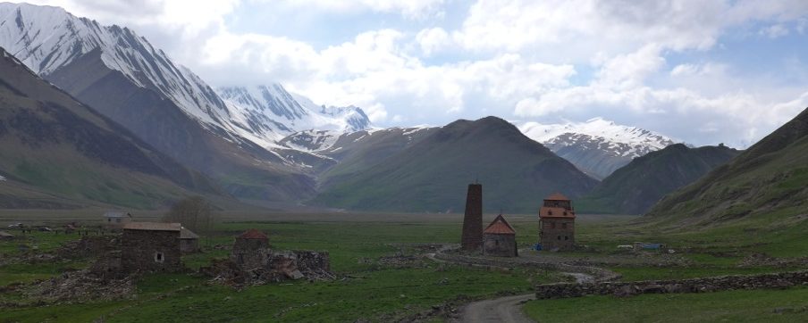
Continuing downstream, you’ll eventually arrive at the entrance to Girevi, marked appropriately with three crumbling koshkebi towers. The old, medieval Girevy village is clinging to the cliffs above the trail. The “new” Girevi village is located in the river valley below.


While the koshki towers are stunning in and of themselves, their construction is equally if not more impressive. Builders often utilized the stone cliffs as the foundation, and rarely are said stone cliffs completely level.


Old Girevi located up above the river.

Coming from Shatili, Girevi is the third and final location in which you’ll need to check in with the Georgian Border Guards. As always, they will have a jolly, well-fed Caucasus Mountain Dog who may be too old and fat to bother with any aggressive behavior. Expect Georgian hospitality at its best – simple conversation, snacks, and warm beverages may very well be provided.

Looking back at Girevi, heading to Parsma and Dartlo. This will be your view of Girevi if you begin your trek in Omalo.


If time permits, the short, steep detour up to Parsma – hidden from view due to its location on a plateau – is well worth your while.

You’ll know you’ve reached Parsma when you see these unique koshkebi commanding both sides of the pass.

Your author did not intend on visiting Parsma – it was actually one of many wrong turns made along this trek. However, it was one of the best.

Parsma is a hidden gem of a village located above the trail, hidden from view, due to its location on an alpine plateau. There is an open clearing overlooking the village – you can drop your pack here and rest peacefully to the sounds of chickens, sheep and pigs, the smells of wood oven fires shifting in the breeze, and the sight of hawks diving in and out of the valley looking for a meal. Local children will likely join you at one point or another. Before you depart, top up on water from the local village spring.

As of this photo, Parsma has not yet been touched by tourism in any significant way. Lets hope it stays that way.

The koshki above Parsma, next to the village cemetery.

And a lone horse, looking for shade, just outside of Parsma.


Your arrival at Dartlo may be one of mixed blessings. While you may be relieved to find a plethora of guesthouses, basic restaurants, and supply shops, it is all accompanied with the downsides of tourism. Dartlo, after all, is the final frontier for most tourists, as it is the only location accessible by car from Omalo. Many will arrive in Omalo, take a car to Dartlo, spend the night, and head back.
In any case, this is a great place to recharge with a meal, a shower, or a night in a comfortable bed. Or all of the above.

In an effort to reduce as much walking on Day Four as possible, your author continued on beyond Dartlo for another hour or two before setting up camp for the night. Rather than crossing the river just south of Dartlo and heading west towards Omalo, the trail to Diklo stays on the north/east (left) side of the river looking downstream.

Continuing downstream, the river to your right, you’ll arrive at Chigo, a small village clinging to the slope (above is the view of Chigo looking back after departure towards Diklo).
Your author encountered only one family in Chigo, a father and son (the rest had already left for the valley, as it was nearly mid-September) who were gracious enough to offer up homemade bread and green beans with fresh oil and garden herbs in their stone home. The heat of the sun contrasted sharply with the cold stones, still emanating cool temperatures from the freezing temperatures the night before. Hung on the walls were photos of fathers and grandfathers and great-grandfathers in traditional Georgian dress with rifles, large knives and embroidered swords.
After the meal, the father pointed to three paths in the direction of Diklo – one high route, one low route, and one middle route. He recommended the middle route – it would follow the ridge before descending down to a bridge over a river, at which point the trail leads up and over one final pass before spilling into Diklo, the only other village with a car to Omalo.

The villagers’ advice in Chigo was spot-on – you’ll encounter a series of steep switchbacks after exiting Chigo before descending rapidly into a draw, at which point you’ll arrive at a gushing river with a sturdy, well-constructed bridge. From the bridge, a series of forested (and shaded) switchbacks will take you up the opposite bank to a distinct pass with panoramic views over the neighboring valleys below.

You’ll encounter a few crumbling shepherd huts along the route.

Once up and over the pass, the trail will again present several switchbacks in your descent to the neighboring valley. You’ll spill out of the forest and turn left/north on the dirt road – it is a relatively short walk from here to Diklo in the distance.
 The center of Diklo is marked by a prominent village well and spring – you can see your authors pack and walking stick resting up against it in the above photo.
After quenching my thirst, I was invited into a neighboring compound by a nice old man and his wife. She quietly set down the scarf she was knitting and served up some hot tea and biscuits while her husband arranged for a car to Omalo.
I sat there watching the old man tinker with his rusted wheelbarrow, his wife finishing up a scarf, and enjoyed the above view from a wooden stump with my back comfortably resting against a cold, mossy stone wall. A cool breeze casually passed through the courtyard while the sun slowly crept up my sore legs, drying my blistered feet in the process. Other than the by now familiar sounds of chickens squawking, the only sounds in the village was from the old man’s squeaky wheelbarrow.
From Diklo, it takes less than an hour to get to Omalo by car.